


| Brand | Accuracy | High | Software | Compatible | Resolution | Fine | Versatility | Flexible |
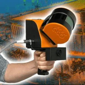
Explore ARD Geographics in Ajman, UAE, your go-to for 3D Laser Scanning. We utilize this technology in construction, land surveying, and agriculture. Our scanning method tracks important points in images to create a 3D map, providing accurate spatial information for various industries. Trust us for precise and detailed scanning services tailored to your needs.
|
Nature of Business Surveying Services |
Year of Establishment 2021 |
Website https://www.ardglobal.com/ |
Working Days Tuesday - Monday 09:00 17:00 |
Trade License 15444 |
Service Area Ajman, United Arab Emirates |
Certified Certified by TradersFind |
ARD Geographics was founded in 2001 and embarked on a journey in geomatics engineering, founding a company with a vision to provide exceptional land survey services in the UAE and the Middle East. We are a prominent leader in professional services across the United Arab Emirates. We are committed to its core mission of assisting with land studies, pledge honesty, timely project completion, and cost-effectiveness for our clients. Explore our offerings at ARD Geographics, with our expert Route Surveyors, Land Surveyors, and Marine Surveyors, all falling under the comprehensive category of Surveyors. We are dedicated to delivering quality services that align with our client's needs and expectations.